Lemmy.one
  • Communities
  • Create Post
  • heart
    Support Lemmy
  • search
    Search
  • Login
  • Sign Up
bysariipek@en.osm.town to OpenStreetMap community@lemmy.ml · 2 years ago

Exciting Update: Mapilio Now Integrated with OpenStreetMap iD Editor! 🌍

cdn.masto.host

message-square
16
fedilink
  • cross-posted to:
  • openstreetmap_it@feddit.it
37

Exciting Update: Mapilio Now Integrated with OpenStreetMap iD Editor! 🌍

cdn.masto.host

bysariipek@en.osm.town to OpenStreetMap community@lemmy.ml · 2 years ago
message-square
16
fedilink
  • cross-posted to:
  • openstreetmap_it@feddit.it

Exciting Update: Mapilio Now Integrated with OpenStreetMap iD Editor! 🌍

Dear Mappers,

🎉🎉 We’re thrilled to share some exciting news 🚀 – Mapilio is now seamlessly integrated with OpenStreetMap’s iD Editor! Your contributions on Mapilio are now easily accessible and editable through the iD Editor, making collaborative mapping more efficient than ever.

https://mapilio.com

@openstreetmap @openstreetmap@lemmy.ml @OpenStreetMapUS @OSM_Pontarlier
#osm #openstreetmap

alert-triangle
You must log in or # to comment.
  • okda@lemmy.ml
    link
    fedilink
    English
    arrow-up
    10
    ·
    2 years ago

    And mapilio is what?

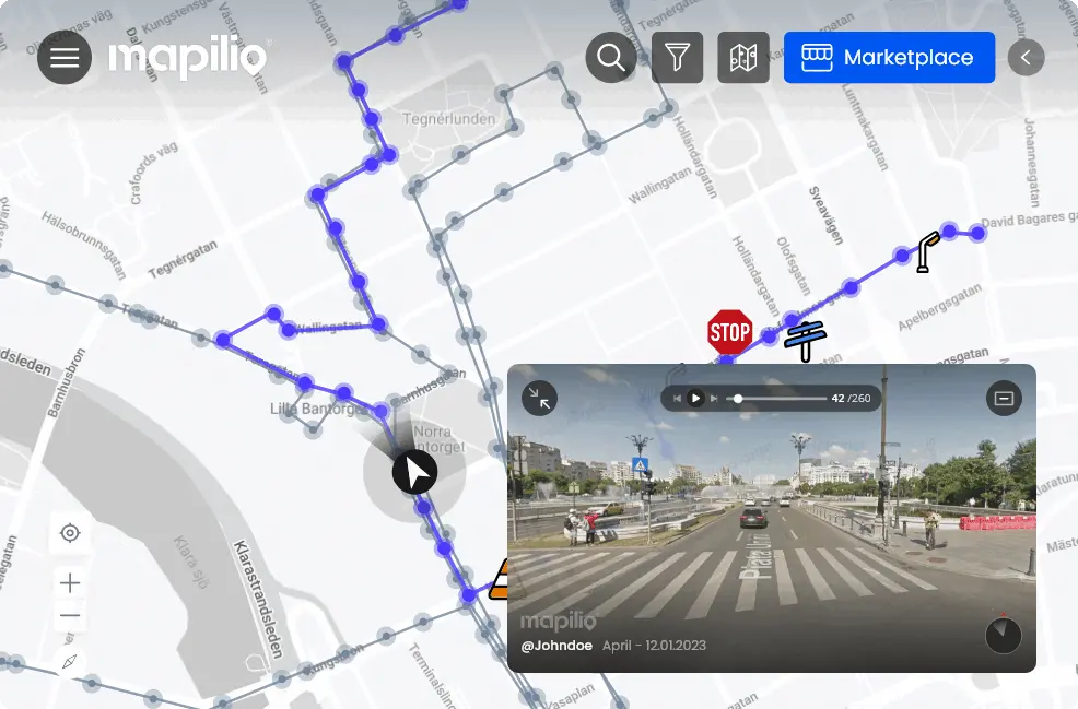
    “Mapilio’s platform creates smart map data using street-level images.”

    Is it the same as mapillary?

    • Mannivu@feddit.it
      link
      fedilink
      English
      arrow-up
      6
      ·
      2 years ago

      Based on this gif on their home page yes, they’re a Mapillary and KartaView alternative.

      • une_abeille@lemmy.ml
        link
        fedilink
        English
        arrow-up
        3
        ·
        2 years ago

        I wonder how one would choose which project to contribute imagery to.

        • JauneBaguette@framapiaf.org
          link
          fedilink
          arrow-up
          1
          ·
          2 years ago

          deleted by creator

        • 𝗧𝗼𝗮𝘀𝘁𝗲𝗿 *𝑣𝑒𝑟𝑦 𝑝𝑢𝑠ℎ𝑒𝑑 𝑑𝑜𝑤𝑛@slrpnk.net
          link
          fedilink
          English
          arrow-up
          1
          ·
          2 years ago

          Mapillary is owned by Facebook but aside from that I’d like to hear other people’s comparisons between them.

          • JauneBaguette@framapiaf.org
            link
            fedilink
            arrow-up
            1
            ·
            2 years ago

            deleted by creator

            • 𝗧𝗼𝗮𝘀𝘁𝗲𝗿 *𝑣𝑒𝑟𝑦 𝑝𝑢𝑠ℎ𝑒𝑑 𝑑𝑜𝑤𝑛@slrpnk.net
              link
              fedilink
              English
              arrow-up
              1
              ·
              2 years ago

              When using both apps, they’re so similar in how images are captured and uploaded. The only other difference I see is that Mapillary has more data which is no surprise since Mapilio is newer. They both have OSM ID integration with Mapillary letting you filter it a tiny bit more. Also Mapilio has a little bit longer upload times.

              So from my perspective, aside from the fact that Mapillary is owned by Facebook and Mapilio is owned by a nonprofit and plans to open source, I do not see much of a difference between the two. Based on my understanding, I’d tend towards Mapilio due to the ownership.

              Is there any functionality or anything else that I’m missing between the two? They’re so similar which is why I was asking.

    • bysariipek@en.osm.townOP
      link
      fedilink
      arrow-up
      3
      ·
      2 years ago

      @okda @Mannivu

      Well, its not the same, although they have similarities in terms of processing and generating data related to mapping and location. Both platforms used for crowdsourced street-level imagery and geospatial data. However, they are distinct services with their own approaches and technologies for collecting, organizing, and analyzing this data. While they may share some common goals, they each have their own unique features and methods for achieving them. 🤟🏻😊

      • Mannivu@feddit.it
        link
        fedilink
        English
        arrow-up
        2
        ·
        2 years ago

        I think that “same” in this case was referring mostly to the goal, more than on the methods involved. I understand they are different under the bonnet, but they do the same thing.

      • 𝗧𝗼𝗮𝘀𝘁𝗲𝗿 *𝑣𝑒𝑟𝑦 𝑝𝑢𝑠ℎ𝑒𝑑 𝑑𝑜𝑤𝑛@slrpnk.net
        link
        fedilink
        English
        arrow-up
        1
        ·
        2 years ago

        Can you please elaborate on their different approaches to collecting, organizing, and analyzing the data as well as their “unique features and methods for achieving them”? It hasn’t been obvious to me what their differences are.

  • Matija Nalis@mastodon.online
    link
    fedilink
    arrow-up
    7
    ·
    edit-2
    2 years ago

    @bysariipek
    I’d just love if #mapilio would open source their mobile apps. I’m avid #fdroid user and don’t want to support closed source projects. And I really don’ get it why they are so against #opensource mobile apps? I mean, all of their bussiness money-making logic seems to be on server-side anyway, and having #FOSS opensource client would be big PR boost and benefit them hugely by helping them grow their community.
    @openstreetmap@en.osm.town @openstreetmap@lemmy.ml @OpenStreetMapUS @OSM_Pontarlier
    @zverik

    • ozcan durak@en.osm.town
      link
      fedilink
      arrow-up
      5
      ·
      2 years ago

      @mnalis @bysariipek @openstreetmap @openstreetmap@lemmy.ml @OpenStreetMapUS @OSM_Pontarlier @zverik

      We appreciate the community’s enthusiastic response. While we aim to reciprocate and give back, our current beta phase entails addressing bugs and security concerns. This is why we’ve refrained from a public app release. Our plan involves launching a stable version before making the platform and mobile apps open source. As Mapilio, our focus is community-oriented rather than profit-driven.

      • cantences@anonsys.net
        link
        fedilink
        arrow-up
        4
        ·
        2 years ago

        @ozcan
        You must first remove the trackers

        anonsys.net/display/bf69967c-8…

        • ozcan durak@en.osm.town
          link
          fedilink
          arrow-up
          0
          ·
          2 years ago

          @cantences

          You’re correct about F-Droid. However, regarding the current application, regrettably, there’s nothing we can currently change. These issues also exist in Kartaview and Mapillary, as most of the trackers are integrated with social logins.

          • cantences@anonsys.net
            link
            fedilink
            arrow-up
            2
            ·
            2 years ago

            @ozcan
            just remove social logins. Problem solved.

            • beta_tester@lemmy.ml
              link
              fedilink
              English
              arrow-up
              1
              ·
              2 years ago

              One of the worst inventions of the 21st century

      • Matija Nalis@mastodon.online
        link
        fedilink
        arrow-up
        2
        ·
        2 years ago

        @ozcan @bysariipek @openstreetmap@en.osm.town @openstreetmap@lemmy.ml @OpenStreetMapUS @OSM_Pontarlier @zverik
        I hope you’ll forgive me if I reserve my belief until such time when said open source materializes. I pledge to send some donations your way as soon as that happens as a sign of goodwill, how about that? Why would your plan prohibit you from publishing (at least some, if there are reasons you can’t yet publish all of it) mobile app open source right now as sign of goodwill? Surely *some* is publishable?

  • Voyager@psychedelia.ink
    link
    fedilink
    English
    arrow-up
    1
    ·
    2 years ago

    Great news! More integrations means more opportunities to improve the map. Thanks for sharing!

OpenStreetMap community@lemmy.ml

openstreetmap@lemmy.ml

Subscribe from Remote Instance

Create a post
You are not logged in. However you can subscribe from another Fediverse account, for example Lemmy or Mastodon. To do this, paste the following into the search field of your instance: !openstreetmap@lemmy.ml

Everything #OpenStreetMap related is welcome: software releases, showing of your work, questions about how to tag something, as long as it has to do with OpenStreetMap or OpenStreetMap-related software.

OpenStreetMap is a map of the world, created by people like you and free to use under an open license.

Join OpenStreetMap and start mapping: https://www.openstreetmap.org/.

There are many communication channels about OSM, many organized around a certain country or region. Discover them on https://openstreetmap.community/

https://mapcomplete.org/ is an easy-to-use website to view, edit and add points (such as shops, restaurants and others)

https://learnosm.org/en/ has a lot of information for beginners too.

Visibility: Public
globe

This community can be federated to other instances and be posted/commented in by their users.

  • 6 users / day
  • 26 users / week
  • 521 users / month
  • 1.26K users / 6 months
  • 45 local subscribers
  • 5.03K subscribers
  • 444 Posts
  • 2.6K Comments
  • Modlog
  • mods:
  • Ben_on_Lemmy@lemmy.ml
  • pietervdvn@lemmy.ml
  • SyJ@lemmy.ml
  • m-p{3}@lemmy.ca
  • BE: 0.19.7
  • Modlog
  • Legal
  • Instances
  • Docs
  • Code
  • join-lemmy.org